


açıklaması SatFinder
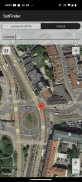
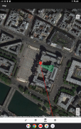
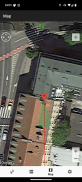
SatFinder (Satellite Finder) is a tool which will help you to set up satellite dish. It will give you azimuth, elevation and LNB tilt for your location (based on GPS) and chosen satellite from list. The result is shown both as numeric data and graphical on google maps. It has also built in compass which will help you to find proper satellite azimuth. It also can use augmented reality to show where is satellite on camera view.
Compass works only on devices with compass sensor (magnetometer).
How to use this app:
1. First of all, you should enable GPS and Internet on your phone. Remember – in most cases it is impossible to receive GPS signal inside buildings. So if you want to get very accurate location – please go near windows or go even outside.
In current app version location should be found quite immediately. So if you stuck with ‘no location’ message please make ensure that you got enabled all required features/permissions.
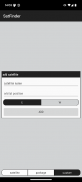
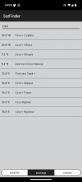
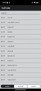
2. If app found your location, you must select desired satellite. To do this you must find icon with magnification glass and tap it. On the list you will find all satellites with elevation angle above zero degrees. Remember: satellite name doesn’t affect the calculation of angles. Important thing is satellite position.
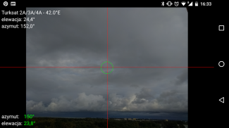
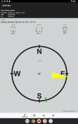
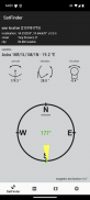
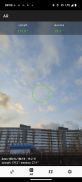
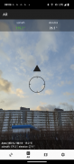
3. The azimuth, elevation and skew angle is calculated for your location and chosen satellite. Under calculated values there is a compass with graphical representation of azimuth angle. The azimuth angle is calculated with magnetic inclination. Remember – every time you use compass – you should calibrate it. Green line represents your phone azimuth. So if on compass green and red indicators are on each other – front of the phone should show you direction to the satellite. If the compass value is correct – phone azimuth value will go green.
SATFINDER (Uydu Bulucu) uydu çanağı kurmak için yardımcı olacak bir araçtır. Size listeden semt, yükseklik ve LNB eğimini konumunuz için (GPS dayalı) ve seçilen uydu verecektir. Sonuç google maps üzerinde sayısal veriler ve grafiksel olarak hem gösterilir. Aynı zamanda uygun uydu azimut bulmak için size yardımcı olacak pusula inşa etti. Aynı zamanda kamera görüntüsü uydu nerede göstermek için genişletilmiş gerçeklik kullanabilirsiniz.
Pusula sadece pusula sensörü (manyetometre) sahip cihazlar üzerinde çalışır.
Bu uygulamayı kullanmak için nasıl:
1. Öncelikle, telefonunuzdaki GPS ve interneti etkinleştirmeniz gerekir. Unutmayın - çoğu durumda binalar içinde GPS sinyali almak mümkün değildir. Eğer çok hassas bir konuma almak istiyorsanız Yani - pencere kenarlarında gitmek veya dışında bile gidin lütfen.
mevcut uygulama sürümü konumda oldukça derhal bulunmalıdır. Eğer 'hayır konumu' mesajı ile sıkışmış Yani eğer gerekli tüm özellikler / izinleri etkin var olmasını sağlamak olun.
Uygulamanın konumunuzu bulduysanız 2. Eğer istenen uyduyu seçmeniz gerekir. Bunu yapmak için büyütme cam simgeyi bulmak ve ona dokunun gerekir. Listede sıfır derecenin üzerinde yükseklik açısı ile tüm uyduları bulacaksınız. Unutmayın: Uydu adı açılarının hesaplanması etkilemez. Önemli olan uydu konumudur.
3. azimut, yükseklik ve eğim açısı bulunduğunuz yere ve seçilen uydu için hesaplanır. Hesaplanan değerler altında azimut açısı grafiksel gösterimi ile bir pusula var. azimut açısı manyetik eğim ile hesaplanır. Unutmayın - Pusulayı kullanmadan her zaman - bunu kalibre edilmelidir. Yeşil Hat telefon azimut temsil eder. Yani pusula üzerindeki yeşil ve kırmızı göstergeler birbirlerine ise - Telefonun ön size uydu yön göstermelidir. pusula değeri doğru ise - telefon azimut değeri yeşil gidecek.


SatFinder - APK Bilgisi
APK sürümü: 1.48Paket: com.esys.satfinderAynı kategorideki uygulamalar
Hoşuna gidebilecekler...


